

Map of the siege of Yorktown, 1781 (Yorktown, Virginia, USA) 37°14'19"N 76°30'34"W published in Philadelphia, 1782
Engraving and etching; printed on paper; hand coloured; reverse window mounted on paper | Scale: 1:14,514 approx. Scale bar: A Scale of Yards [63 mm =] 1000. (scale) | RCIN 734069
 37?14'19")
Robert Scot (active 1782)
Map of the siege of Yorktown, 1781 (Yorktown, Virginia, USA) 37?14'19"N 76?30'34"W published in Philadelphia, 1782
 37?14'19")
-
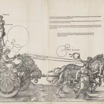
A map of Yorktown, besieged by the French and Americans commanded by General George Washington (22 February 1732–14 December 1799) and Jean Baptiste Donatien de Vimeur, comte de Rochambeau (1725-1807), and surrendered by the British, commanded by Lieutenant-General Lord Charles Cornwallis (1738-1805). American War of Independence (1775-83). Oriented with north-north-east to top.
The siege of Yorktown lasted from 29 September to 19 October. About 9,000 British troops, including Germans, were besieged and defeated by a combined 19,000-strong French and American army.
This rare map has been described as a cornerstone document of American national heritage. Only twelve copies are known in the USA. It is the only known American survey of the culminating battle of the war, and shows the investiture of Yorktown, with the American trenches and ‘The Field where the British laid down their Arms’. The American forces are shown in blue, the French in yellow, and the British in red. It was advertised for sale in The New York Packet and the American Advertiser in March 1782.
The map was reproduced in 1825 by John Francis Renault and Benjamin Tanner; in about 1887 by the New England Historic Genealogical Society; 1976 by Meridian Gravure Company and again in 1981 by the United States Defense Mapping Agency.
Additional text: [bottom centre, in rococo cartouche embellished with the artefacts of war with the union flag on the right, and French flags on the left, a descriptive key, A-I, K-R:] THIS PLAN was taken between the 22nd & 28th of October, 1781. / Explanation [top left, in cartouche representing a scroll, a key, 1-22:] References to the British Lines.
Condition: one fold line.Provenance
From the collection of military and naval maps and prints formed by George III (1738-1820)
-
Creator(s)
(engraver)Acquirer(s)
-
Medium and techniques
Engraving and etching; printed on paper; hand coloured; reverse window mounted on paper
Measurements
Scale: 1:14,514 approx. Scale bar: A Scale of Yards [63 mm =] 1000. (scale)
64.2 x 44.9 cm (image)
[top cropped] x 45.2 cm (platemark)
71.7 x 51.3 cm (mount)
65.6 x 45.8 cm (sheet) (whole object)
Markings
watermark: Fleur-de-lys in crowned shield, the letters G R below; countermark: J WHATMAN
annotation: Old heading: [black pencil, underlined in red ink:] York and Gloucester 29 Sept. 1781. Other annotations: none.
Category
Object type(s)
Subject(s)
Bibliographic reference(s)
Verner, C., ‘Maps of the Yorktown Campaign, 1780-81: a preliminary check list of printed and manuscript maps prior to 1800’, Map collectors’ Circle, 1965 XXVI
Alternative title(s)
To His Excellency Gen.l Washington / Commander in Chief of the Armies of the / United States of America, / This Plan of the investment / of York and Gloucester has been sur- / veyed and laid down, and is / Most humbly dedicated by his Excellency’s / Obedient and very humble servant / Sebast.n Bauman. Major / of the New York or 2nd Reg.t / of Artillery.
York Plan of the Investment of York and Gloucester in Virginia by the French and American Forces commanded by Count Rochambeau and General Washington, on the 29.th of Sept.r 1781: by Major S. Bauman, 1781; engraved by R. Scot, 1782.
 after Sebastian Bauman (fl. 1776–83), The Battle of Yorktown (October 1781), 1782. Engraving with some hand colouring, 65.5 x 45.9 cm. RCIN 734069")


